Bowdoin National Wildlife Refuge Compact
This compact settles the reserved water rights on the refuge for uses that include administrative, wildlife habitat maintenance and enhancement, and stock watering. The USFWS water rights are contingent on a memorandum of understanding (MOU) that outlines provisions relating to mitigation of severe salinity problems on the refuge. The MOU was approved by all parties in April 2013. The compact was approved by the United States in March 2014 and approved by the Montana Water Court in October 2015. The Montana Water Court issued its Final Judgment in May 2016.
The Montana Reserved Water Rights Compact Commission (RWRCC) and the United States Fish and Wildlife Service (FWS) negotiated the Bowdoin National Wildlife Refuge (the Refuge) compact between 1995 and 2007
Bowdoin National Wildlife Refuge, located in Phillips County near Malta, was established in 1936 and expanded in 1940 to be a refuge and breeding ground for migratory birds. The now-15,551 acre Refuge is utilized by nearby communities as an environmental education resource and it draws in tourist dollars for sightseeing and hunting. Most of the Refuge lands were originally part of the Bureau of Reclamation’s Milk River Project.
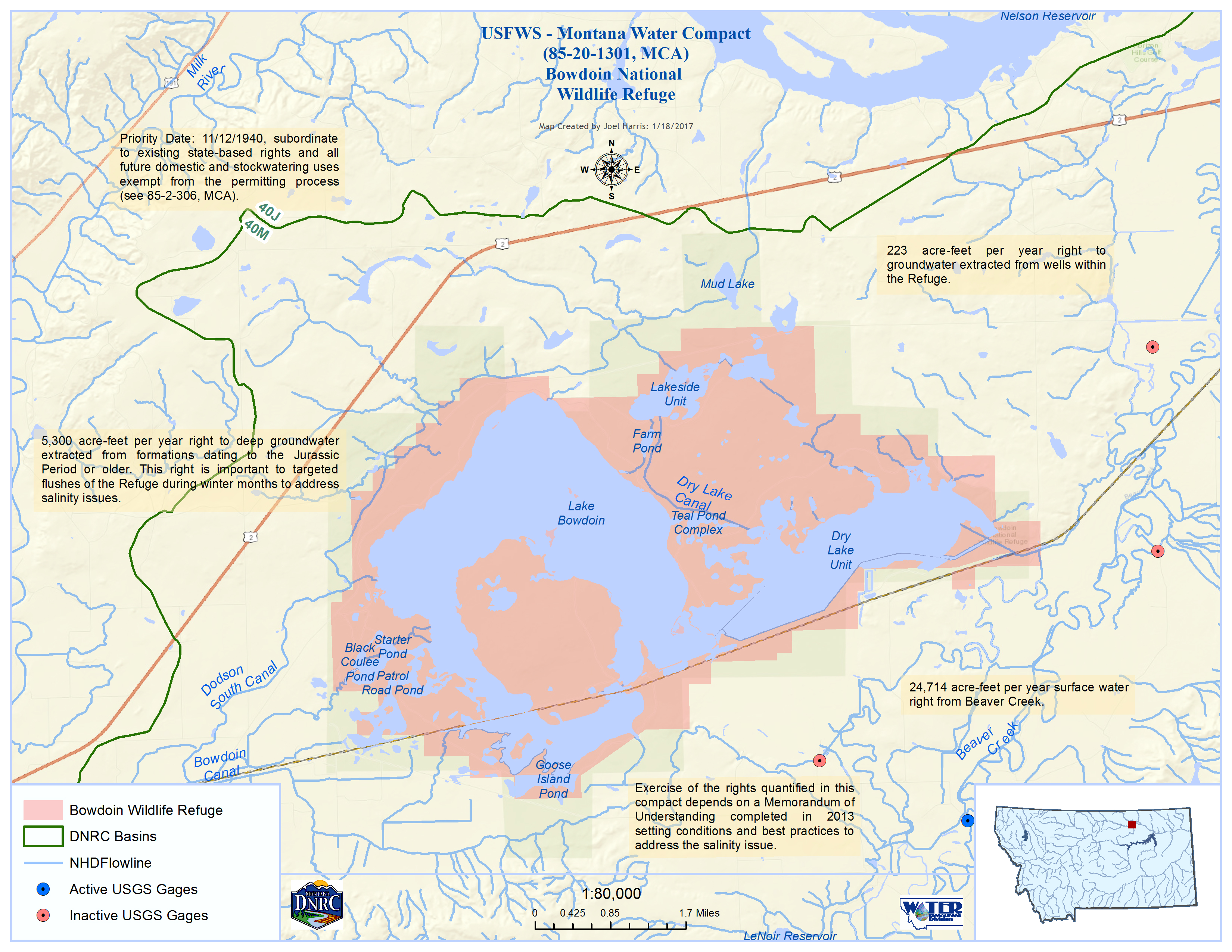
The lands comprising the Refuge sit in a low-lying area alongside the floodplain of Beaver Creek in what is thought to be an old oxbow of the pre-ice age Missouri River. Historically, these lands were fed by large floods that spilled out of the banks of Beaver Creek, creating wetlands. With the development of the Milk River Project, these lands began to receive irrigation return flows from the Project along with some direct deliveries via the Dodson Canal. Diking installed after the creation of the Refuge reduced the ability of the Refuge lands to receive flood flows from Beaver Creek. At the same time, water development upstream has contributed to a reduction of those flows on Beaver Creek, further diminishing the supply of fresh water available to the Refuge. In the early years of the Refuge, FWS managers tried to conserve their water supply by limiting the volume of water released from the Refuge. This, in turn, caused a buildup of salts, which, for a time, was desirable because it created a saline ecosystem that was very good for waterfowl. But as salts continued to increase and water quality laws became more stringent, the Refuge was prohibited by law from releasing any water at all. Irrigation return flows have also become a source of additional salt which continue to accumulate in the Refuge. Currently, the only way salts can escape the Refuge is when winds blow salt crusts away, or when large Beaver Creek floods enter the refuge wetlands and push some of the saline water downstream into Beaver Creek. Neither of these are sustainable management strategies, especially as large salt/dust storms and occasional releases of saline water have caused problems on neighboring properties. The Refuge is presently embarking on a comprehensive planning process to determine how best to address its long-term management options. Quantifying the Refuge’s federal reserved water rights in the proposed Compact is a first step toward ensuring the sustainability of the Refuge as positive rather than negative part of its community.
The Compact recognizes federal reserved water rights for the Bowdoin National Wildlife Refuge from three sources – surface flows from Beaver Creek, surface flows that drain naturally into the Refuge (predominantly from Black Coulee), and ground water. These water rights may be used for the purposes of the Refuge, including wildlife maintenance and enhancement, stock watering, and administrative, institutional, dust suppression and emergency fire suppression uses. These federal reserved rights are subordinated to all water rights existing under State law as of the Effective Date of the Compact (3/5/2014), as well as to all future development excepted from State permitting law (such as small domestic and stock uses). The Refuge’s federal reserved rights are also conditioned on the execution of a Memorandum of Understanding that will establish additional restrictions on the use of these rights to ensure that they do not exacerbate the Refuge’s salt problems. It is also worth bearing in mind that the Water Court basin in which the Refuge is located (Basin 40M) was closed to new surface appropriations by the Legislature in 2001 as part of its ratification of the Ft. Belknap Water Rights Compact. Below is a summary of the key provisions of the Compact.
Federal Reserved Water Rights:
Subject to the subordination requirement, the Compact assigns the FWS federal reserved water rights for:
Deep Ground Water:
A relatively unique aspect of this Compact is the manner in which it addresses the Refuge’s groundwater rights. In the negotiations, FWS made a request for recognition of a significant groundwater right. The RWRCC was concerned about the potential impacts of such a right for two reasons. First, the RWRCC wanted to ensure that any such right would not harm existing users. Second, RWRCC worried about the risk to those who might develop a groundwater right in the future who could potentially still be displaced by the FWS by virtue of the senior priority of an undeveloped federal reserved right. At the same time, the RWRCC recognized that the introduction of new water into a water-short area would be of benefit to both the FWS and the off-Refuge community. The Compact’s subordination provisions addressed the RWRCC’s first concern. The second concern is addressed by requiring that the bulk of FWS’ groundwater right may only be satisfied with water extracted from such a deep aquifer that the FWS would not to be able to deplete it unilaterally. For legal purposes, this depth requirement is defined in the Compact as a requirement that the FWS may only exercise the right by drilling wells into geologic formations of the Jurassic Period or older. Such formations are likely located at least 2600 feet beneath the Refuge’s surface and are relatively straight-forward for a well driller to identify. The Compact also requires the FWS to comply with State permitting requirements (including water quality standards) prior to developing its deep groundwater right.
The Compact settles all federal reserved water rights of the FWS on behalf of the Refuge. FWS and the RWRCC remain in negotiation over FWS federal reserved water rights claims for the C.M. Russell National Wildlife Refuge and the National Bison Range. FWS also retains one claim on behalf of the Refuge based in state law that is in the adjudication process and is not part of this agreement. Nothing in this Compact recognizes a federal reserved water right for the Refuge from the Milk River or from water claimed by the U.S. Bureau of Reclamation or other water users on behalf of the Milk River Project.
Public Input:
All negotiating sessions were noticed and open to the public. In addition, in 2004 RWRCC staff convened an ad hoc local advisory committee comprised of irrigators and other community members concerned about and/or affected by the salt problems at the Refuge for the purpose of soliciting feedback about proposed settlement concepts. Additional meetings with interested individuals and groups have also been held. On February 6 and 7, 2007, RWRCC Commissioner Gene Etchart and RWRCC staff held two open houses in Malta, Montana, to visit with and receive input from interested members of the public about the proposed Compact.