Floodplain Mapping Information for Landowners
Flood maps are one tool that communities use to know which areas have the highest risk of flooding. FEMA maintains and updates data through flood maps and risk assessments.
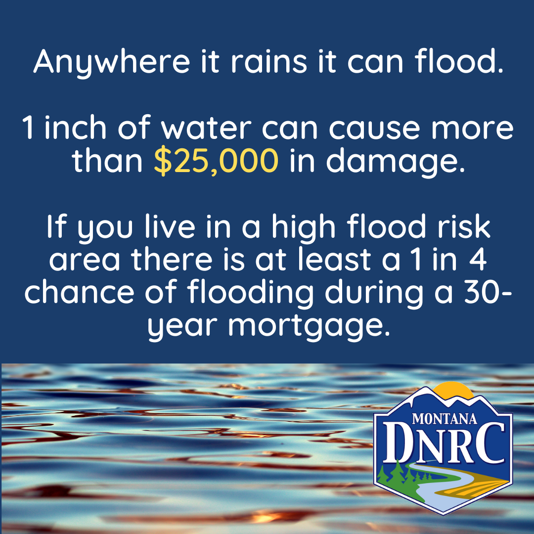
Flood maps show how likely it is for an area to flood. Any place with a 1% chance or higher chance of experiencing a flood each year is considered to have a high risk. Those areas have at least a one-in-four chance of flooding during a 30-year mortgage.
Floods don’t follow city limits or property lines. Using a flood map, you can see the relationship between your property and the areas with the highest risk of flooding. There is no such thing as a “no-risk zone,” but some areas have a lower or moderate risk.
Floodplains are areas along a waterway that are prone to flooding. Flooding can happen anywhere, but certain areas are especially prone to flooding from waterways.
Flood maps show your community’s risk of flooding. They are used for local floodplain regulations, flood insurance requirements, emergency planning, and can help a community plan for future changes by showing high-risk areas.
Floodplains are mapped to show your flood risk. Understanding flood risk is the first step toward flood protection. Accurate maps help residents, businesses, and local officials make informed decisions. They help ensure personal safety, protect financial assets, and plan for emergencies.
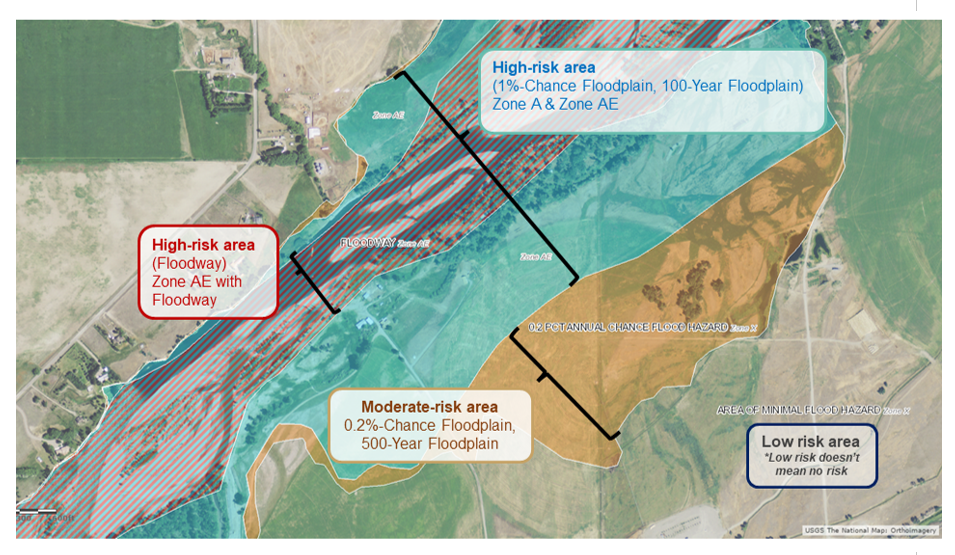
A 100-year floodplain is a high-risk flood zone. They are also called Special Flood Hazard Areas. It means there is a 1% chance of the area flooding every year. During a 30-year mortgage, that means a 1 in 4 chance of flooding.
Newer maps show high-risk areas as an “A”, “AE”, “AO” or “AH” zone. Low- and moderate-risk areas are shown as X zones and shaded X zones on the new maps.
The 100-Year Floodplain is the area designated by the Federal Emergency Management Agency (FEMA) as a HIGH-RISK area for floodplain management and flood insurance purposes.
A 100-YEAR FLOODPLAIN (1% Annual Chance Floodplain) is considered to have a HIGH flood risk. It is the area that is expected to be inundated by a 100-Year Flood, an event having a 1% chance of being equaled or exceeded in any given year. The 100-Year Flood is also referred to as a 1% Annual Chance Flood or a Base Flood.
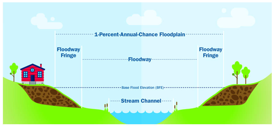
A FLOODWAY is the area within a 100-Year Floodplain that must be kept free from new development so that the 100-Year Flood (1% Annual Chance Flood, Base Flood) can be carried without substantial increases in flood heights. The Floodway will usually see the highest water velocities and deepest inundation during a 100-Year Flood event.
There are many different terms used to describe flood risk. Everyone lives in an area with some flood risk—it’s just a question of whether you live in a high-risk, low-risk, or moderate-risk flood area.
To view your property to see if you are located in a high or moderate flood risk zone visit FEMAs national flood hazard layer or FEMA's map service center.
The mapping follows FEMA/State standards which do not evaluate future conditions such as climate change. However, it is important that community officials, planners, and those working with floodplains are knowledgeable in the changes of watersheds and the weather extremes that are taking place in Montana.
Here are some resources that can be used to increase a community’s resilience in the face of climate change.
Channel Migration Zones the area within which a river channel is likely to move over a period of time is often referred to as the channel migration zone. Channel Migration Zone (CMZ) mapping is based on the understanding that rivers are dynamic and move laterally across their floodplains through time.
FEMA Resources for Climate Resilience assists FEMA’s state, local, tribal, and territorial (SLTT) partners in navigating the FEMA resources that are available to support communities in mitigating impacts of climate change.
EPA’s Adaptation Resource Center (ARC-X) is an interactive resource to help local governments effectively deliver services to their communities even as the climate changes. Decision makers can create an integrated package of information tailored specifically to their needs.
A levee is a man-made structure that is made of an earthen or concrete embankment to help contain, control, or move the flow of water during a flood. While levees may help reduce the risk of flooding, they do not eliminate the risk. Levees can and do deteriorate over time and must be maintained to retain their effectiveness. During flood map updates, certain criteria must be met in order to show the levee as providing a reduced flood risk on the floodplain map. The levee owner needs to provide data and documentation certified by a professional engineer that the levee meets FEMA’s levee engineering standards.
Levees are not fail-proof, and each levee – and flood event – will be different. Levees may be able to hold one storm event but not be able to hold the next one. In some cases, levees can also increase flood risk by diverting floodwater towards other communities.
As a community with a levee, we will experience significant flooding at some point. That is why the levee was built. But it is impossible to know just how high or fast floodwaters will get during an event, which is why it’s important to consider other options to reduce that risk.
If rains are heavy, floodwaters may run up and over the levee and reach nearby structures. This is called overtopping. In heavier storms, floodwaters can also damage levees and cause a breach or opening for floodwater to flow through.
Most roads or other embankments were not designed or constructed as levees. During flood events, roads, embankments, and other manmade structures can and do fail. During flood map updates, in order for a man-made structure to show it reduces the risk for nearby properties, it needs to meet engineering standards outlined by FEMA.
Levees MAY reduce flood risk; they do not remove the risk completely. No flood event or levee is the same. A levee that can hold floodwater for one event may not be able to for the next. With enough flow, floodwaters may run over the top of the levee and reach nearby structures. Over time, a levee’s structural strength can also decline. In heavier storms, floodwaters can erode levees; this can make an opening for water to flow through.
To learn more about how levee risk is determined for floodplain maps click here to view the Levee Brochure.
The best way to protect yourself is to buy flood insurance. Visit floodsmart.gov to learn more.
Learn more about living with levees: fema.gov/flood-maps/living-levees.