Dawson, Fallon, and Powder River Counties have been working with the Federal Emergency Management Agency (FEMA) and Montana Department of Natural Resources and Conservation (DNRC) to produce new and updated 1% annual chance (100-year) floodplain maps. The project includes updating all the existing mapped floodplains for the Yellowstone River and Tributaries through Dawson County, Sandstone Creek and tributaries through Fallon County, and the Powder River and Little Powder River through Powder River County.
Updated floodplain maps will depict the latest, most accurate flood risk data, and will eventually result in updated FEMA floodplain maps. Most of the existing FEMA floodplain maps are based on old data and needs to be periodically updated. For more information see: Floodplain FAQs Flood Study Process
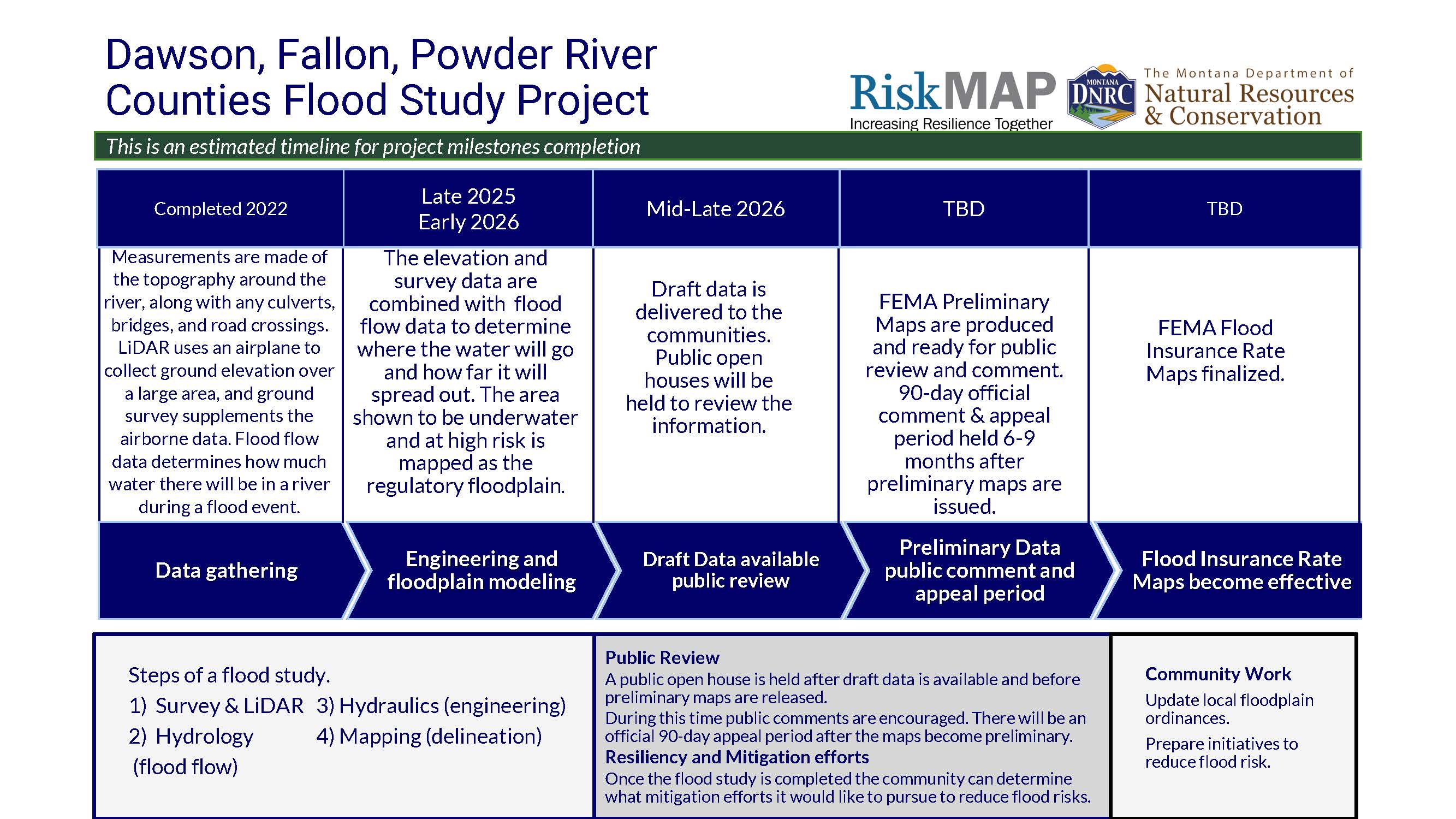
Project Timeline
Flood Insurance Rate Maps indicate areas of flood risk. Once this project is complete, new and updated Flood Insurance Rate Maps will provide more accurate, current, and detailed data and mapping of flood risk areas. New floodplain studies involve collecting and analyzing data, including : topography, hydrology analyses and hydraulic analysis.
Project Updates
Data development is currently underway for all three counties check back for project updates and the availability of draft data when data development is complete.
Project Kick Off Meetings
September 20, 2022 | Fallon County | view handout
SSeptember 21, 2022 | Dawson County | view handout
SSeptember 20, 2022 | Powder River County | view handout
State Flood Hazard Viewer
Draft Data is not yet complete for the project areas. Once the data is complete it will be loaded onto the State Flood Hazard Viewer to share with the public.
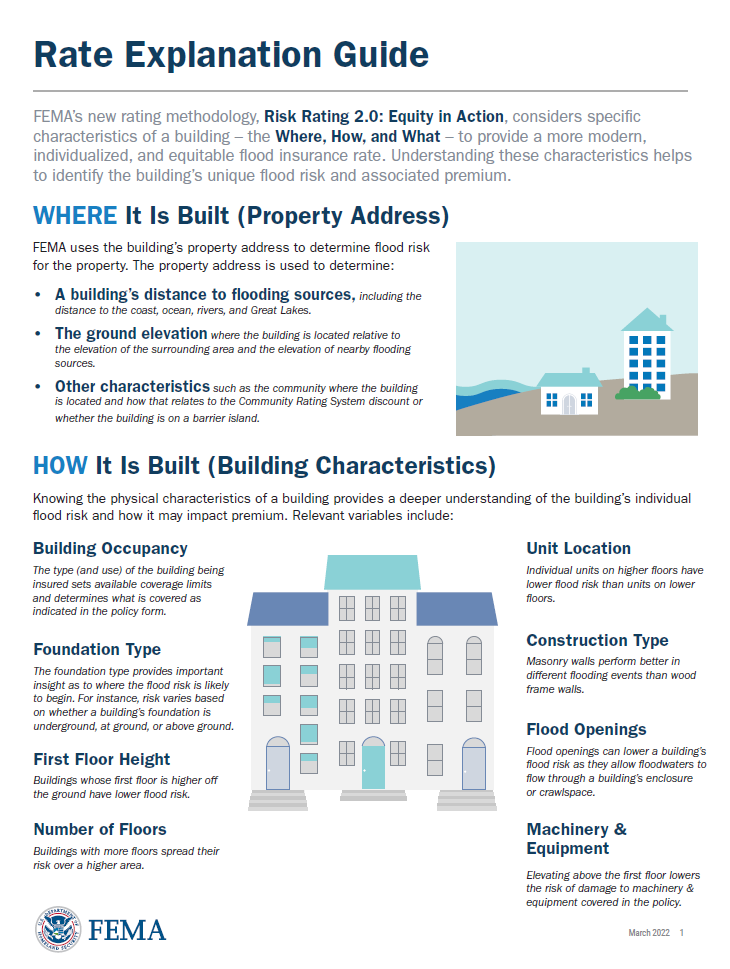 FEMAs Flood Insurance Rate Explanation Guide
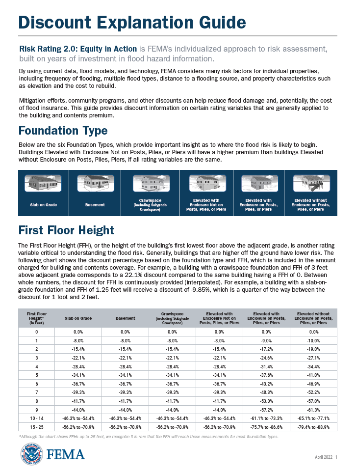 FEMAs Discount Explanation Guide
Contact Information
For more information on the project please contact the local floodplain administrators.
Dawson County
Forrest Sanderson
ForrestSanderson@PeaksPlanning.onmicrosoft.com
(406) 794-1460
City of Glendive
Frank Ceane
ceanef@midrivers.com
(406) 377-3318
Fallon County
Forrest Sanderson
ForrestSanderson@PeaksPlanning.onmicrosoft.com
(406) 794-1460
City of Baker
Kevin Dukart
dukartk@bakermontana.us
(406) 778-2692
Powder River County and The Town of Broadus
Raymond Ragsdale
townofbroadus@rangeweb.net
(406) 935-2242