
The Milk River communities have been working with the Federal Emergency Management Agency (FEMA) and Montana Department of Natural Resources and Conservation (DNRC) to produce new and updated 1% annual chance (100-year) floodplain maps. The project includes updating all the existing mapped floodplains in Hill, Blaine, Phillips, and Valley Counties.
Updated floodplain maps will depict the latest, most accurate flood risk data, and will eventually result in updated FEMA floodplain maps. Most of the existing floodplain maps across all 4 counties are based on data collected in the 1970s. For more information see: Floodplain FAQs Flood Study Process
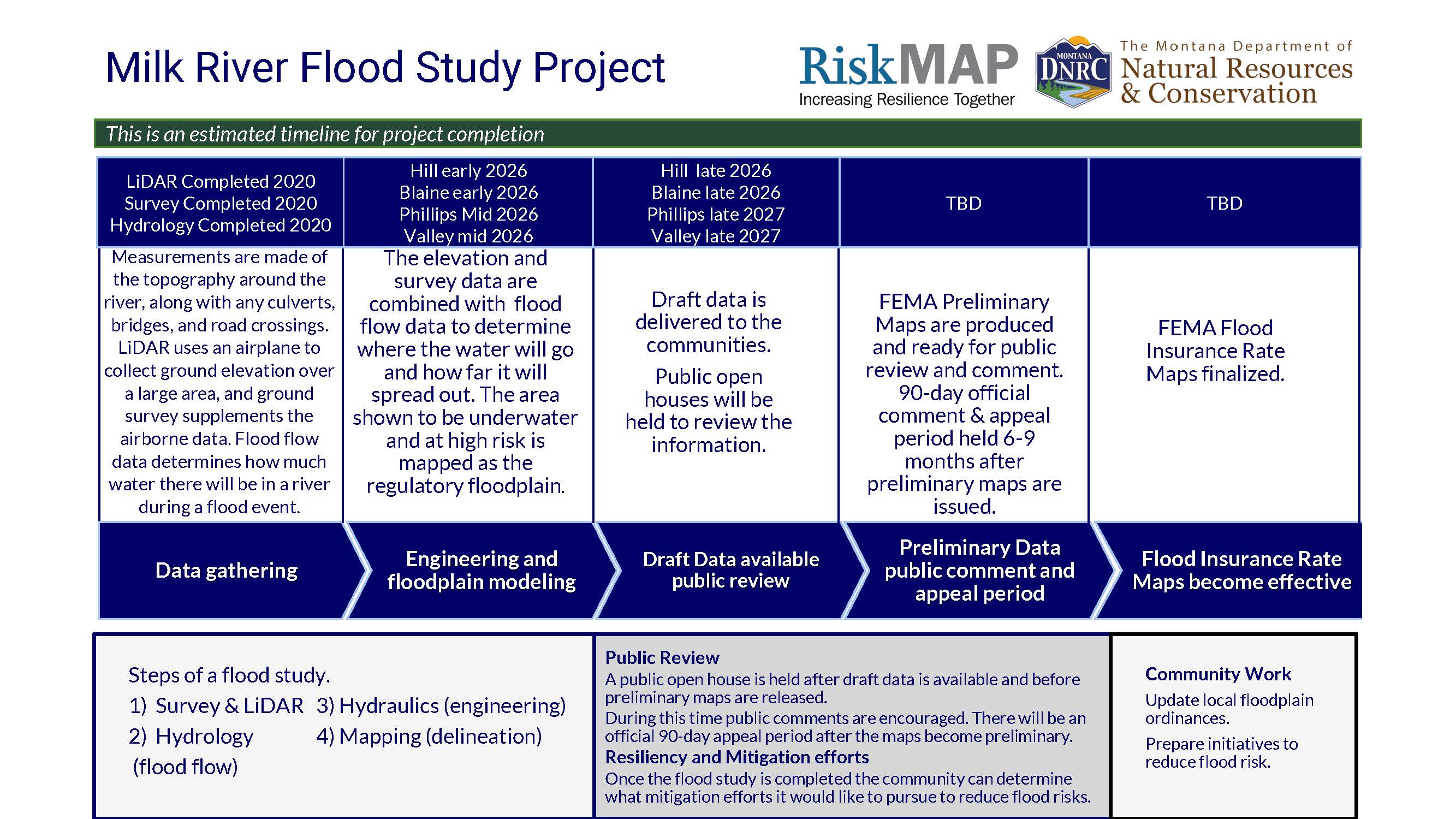
Project Timeline
Flood Insurance Rate Maps indicate areas of flood risk. Once this project is complete, new and updated Flood Insurance Rate Maps will provide more accurate, current, and detailed data and mapping of flood risk areas. New floodplain studies involve collecting and analyzing data, including topography, hydrology analyses and hydraulic analysis.
Project Updates
Data development is currently underway for all four counties check back for project updates and the availability of draft data when data development is complete.
Project kickoff meetings
November 5, 2019 Hill County/City of Havre | view slidesNovember 6, 2019 Blaine County/ City of Chinook | view slides
November 6, 2019 Phillips County/ City of Malta | view slides
November 7, 2019 Valley County/ City of Glasgow | view slides
State Flood Hazard Viewer
Draft Data is not yet complete for the project areas. Once the data is complete it will be loaded onto the State Flood Hazard Viewer to share with the public.
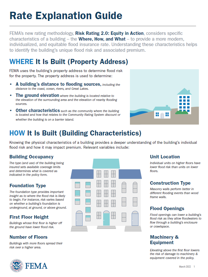 FEMAs Flood Insurance Rate Explanation Guide
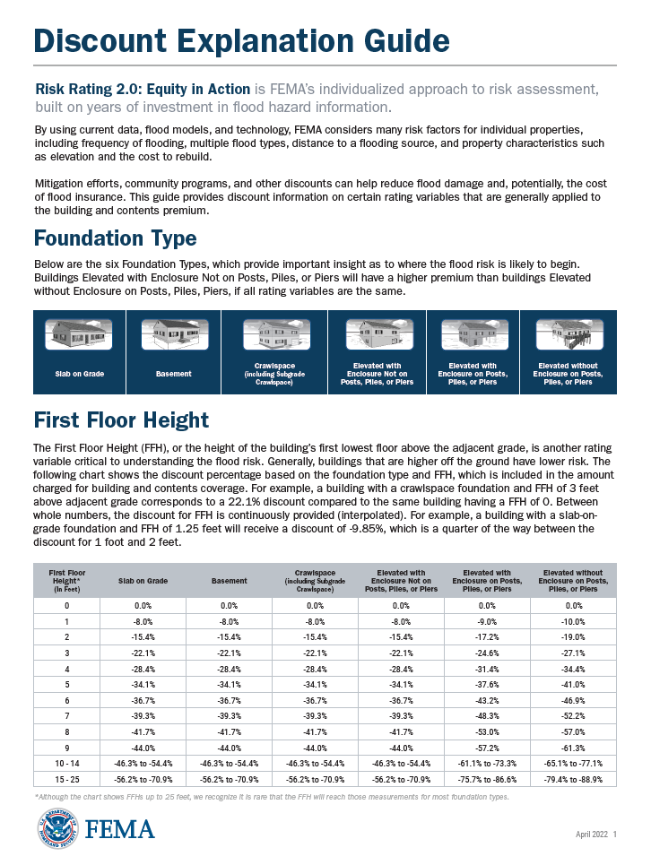 FEMAs Discount Explanation Guide
Contact Information
For more information on the project please contact the local floodplain administrator.
Hill County
Julie Anez
anezj@hillcounty.us
(406) 400-2310
City of Havre
Trevor Mork
tmork@ci.havre.mt.us
(406) 265-4941
Town of Hingham
Thomas Peterson
hinghammtmayor@gmail.com
(406) 579-6858
Blaine County/ Chinook/ Harlem
Shawn Higley
Shigley@wwwcengineering.com
(406) 443-3962
Phillips County
Casey Burke
casey38@gmail.com
(406) 270-1884
City of Malta
John Wright III
complianceofficer@cityofmalta.com
(406) 654-2687
Town of Dodson
Frank "Skip" Cole
townofdodson@itstriangle.com
(406) 241-9688
Town of Saco
Ernie Miranko
townofsaco@nemont.net
(406)527-3312
Valley County
Cam Shipp
cshipp@valleycountymt.gov
(406) 228-6264
City of Glasgow
Paul Skubinna
pskubinna@cityofglasgowmt.com
(406) 228-2476
Town of Nashua
Christina Washington
townofnashua@nemont.net
(406) 746-3461