Missoula County and the City of Missoula have been working with the Federal Emergency Management Agency (FEMA) and Montana Department of Natural Resources and Conservation (DNRC) to produce new and updated 1% annual chance (100-year) floodplain maps. The project includes updating all the existing mapped floodplains for the for the Clark Fork River, Bitterroot River, Rock Creek, and Rock Creek Tributaries.
Updated floodplain maps will depict the latest, most accurate flood risk data, and will eventually result in updated FEMA floodplain maps. The existing floodplain maps are based on data from the 1970s. For more information see: Floodplain FAQs and the Flood Study Process.
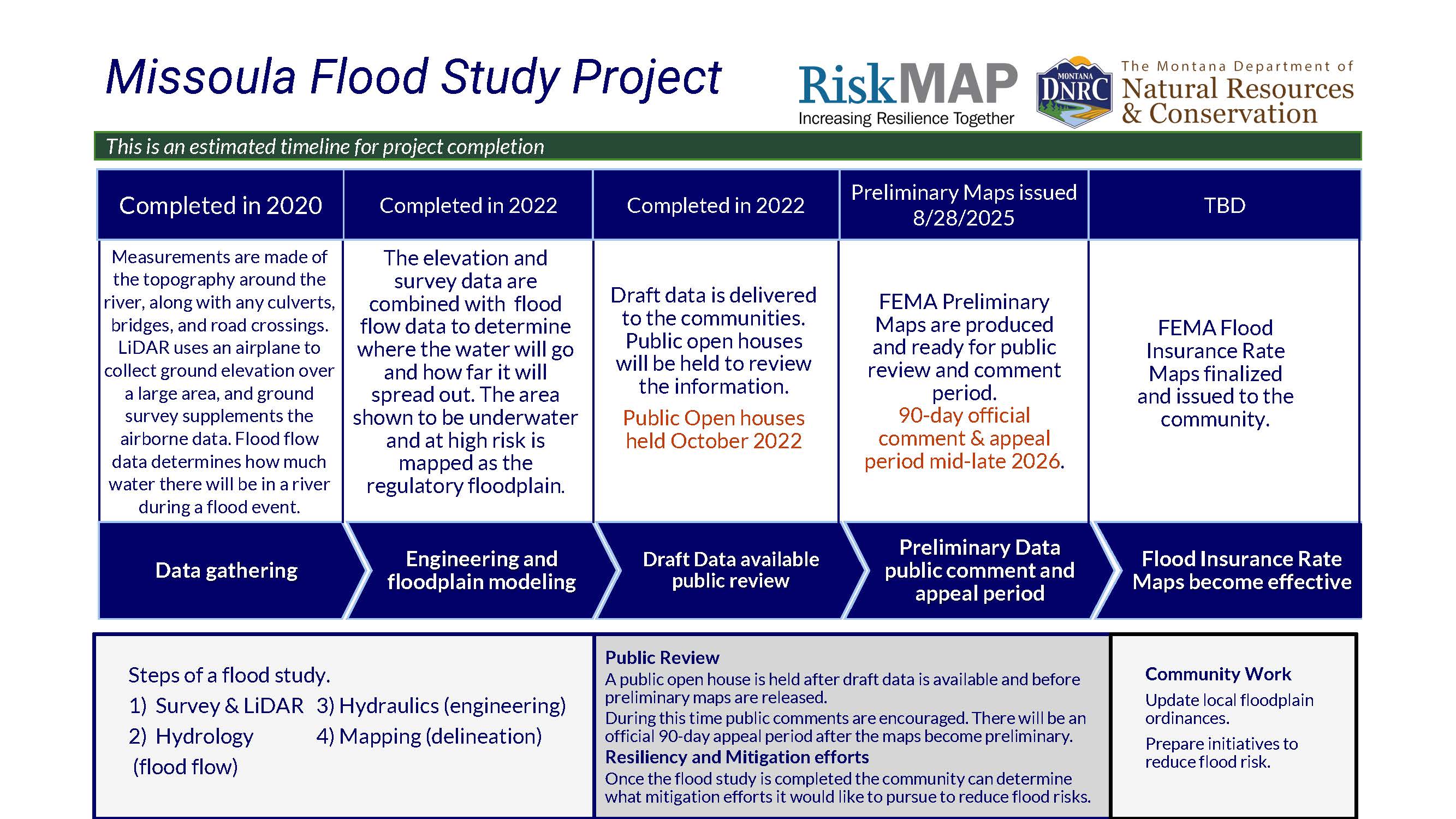
Project Timeline
Flood Insurance Rate Maps indicate areas of flood risk. Once this project is complete, new and updated Flood Insurance Rate Maps will provide more accurate, current, and detailed data and mapping of flood risk areas. New floodplain studies involve collecting and analyzing data, including: topography, hydrology analyses, and hydraulic analysis.
Project Updates
Granite County
Granite County and the Town of Drummond Flood Insurance Rate Maps have gone effective as of August 19, 2025. Please contact the local floodplain administrators to learn more.
Missoula County
Preliminary Flood Insurance Rate Maps and the Preliminary Flood Insurance Study have been issued as of August 28, 2025. Preliminary maps can be viewed here on FEMA's Map Service Center, on the State Flood Hazard Viewer (link below), or hard copies will be available at County and City offices. Instructions to access FEMAs map service center and the National Flood Hazard Layer are shown below.


Link to FEMAs Map Service Center FEMA Flood Map Service Center | Welcome!
Link to FEMAs National Flood Hazard Layer FEMA's National Flood Hazard Layer (NFHL) Viewer
Meeting Information
Coordinating Consultation Officer Meetings
November 6, 2025 | Missoula County | view slides | view minutes
November 12, 2025 | City of Missoula | view slides | view minutes
Public Open House Meetings for Missoula County and the City of Missoula:
Oct 18, 2022 | Commercial Building at the Missoula Fairgrounds | view slides | view video recording
Oct 19, 2022 | Lolo School Lower Gym Lolo | view slides | view video recordingOct 20, 2022 | Missoula County Courthouse Sophie Moiese Room | view slides | view video recording
Project Kickoff Meetings
October 23, 2019 with Missoula County and the City of Missoula. | view slides
View Preliminary Flood Insurance Rate Maps
The preliminary flood study information and maps need to go through a lengthy technical and public review process before being finalized. When finalized, new maps could have effects on some property owner in mapped floodplains.
Know your Property's Flood Risk
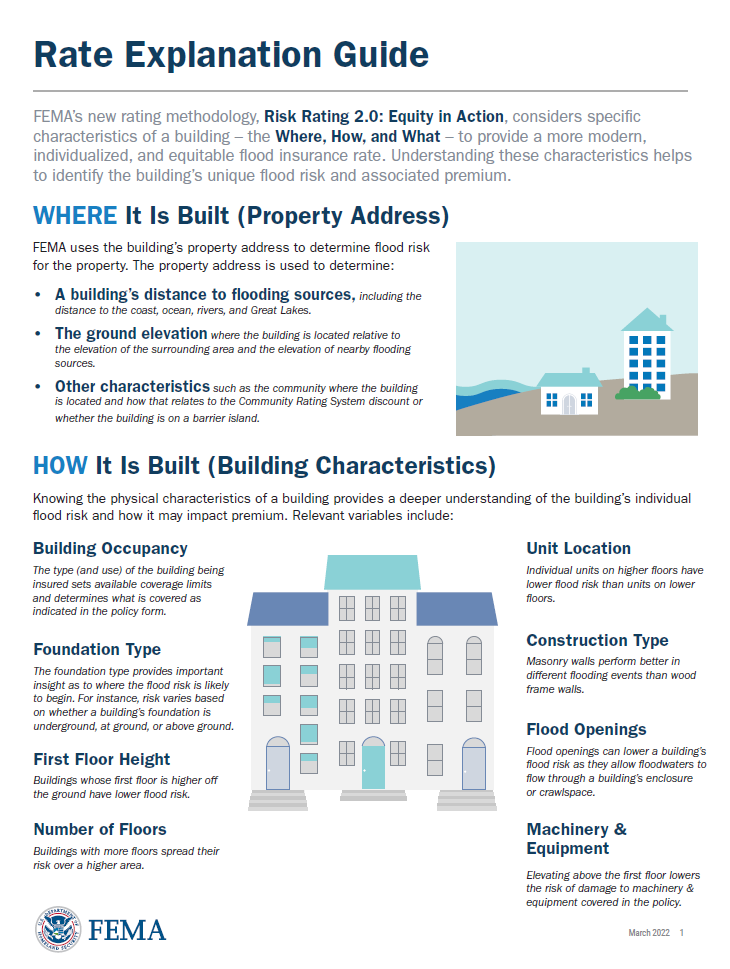 FEMA Flood Insurance Rate Explanation Guide
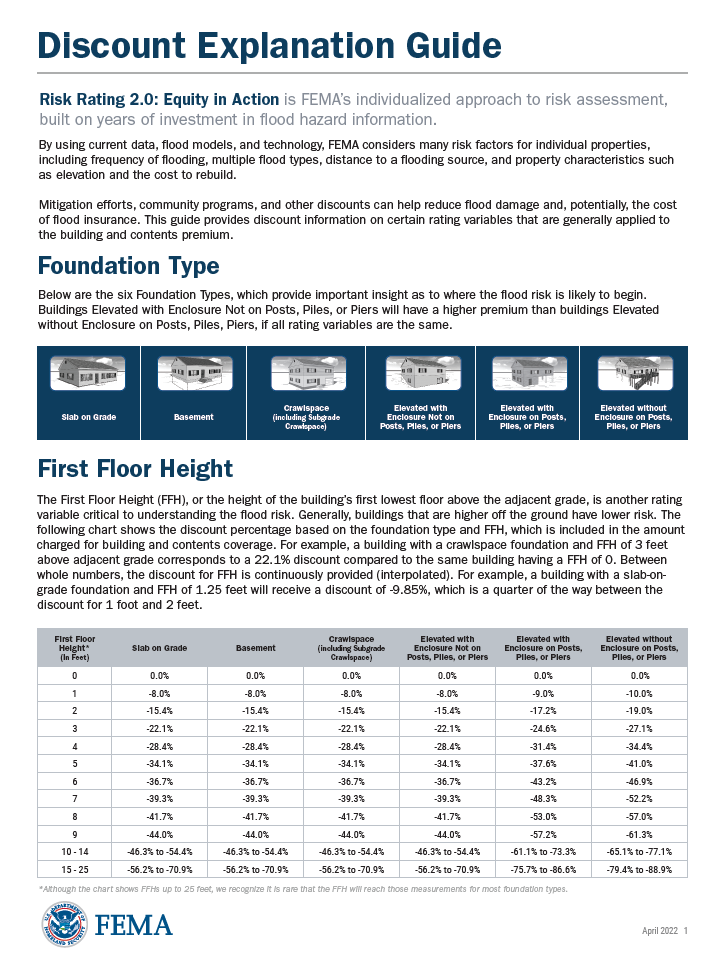 FEMA Flood Insurance Discount Explanation Guide
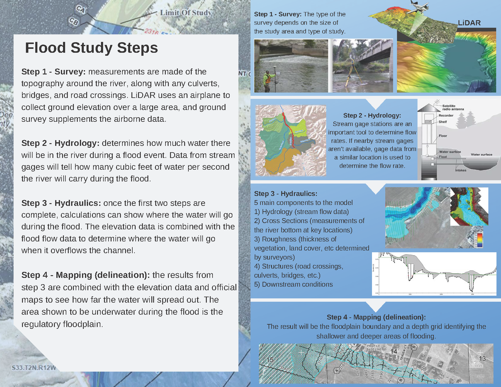
Flood Study reports are available from the local Floodplain Administrator upon request.
Contact Information
For more information on the project please contact the local floodplain administrators.
Missoula County
Matt Heimel
mheimel@missoulacounty.us
(406) 258-4657
City of Missoula
Cassie Tripard
tripardc@ci.missoula.mt.us
(406) 552-6673